TUCKER DIRECTIONS!

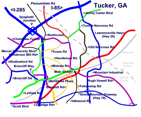
Reading the Map: The short BLACK line in the middle of the map is Tucker Main Street. Atlanta is 14 miles to the southeast(bottom left).
The blue lines: I-85(Northeast Express) is at the top left. Spaghetti junction is the flower on I-85 where it is crossed by I-285. The other blue road crossing I-85 is Jimmy Carter Blvd which is further northeast on I-85. The blue road at the bottom(south) that intersects with both I-285 and Jimmy Carter Blvd is Stone Mountain Freeway/Hwy 78. The remaining blue road on the map is Briarcliff Rd which runs from LaVista past NorthLake Mall and then curves toward Atlanta. (N.B. Briarcliff and LaVista also intersect in Toco Hills--I missed an appointment once because I was at the WRONG Briarcliff and LaVista!)
The interchanges shown from Atlanta on I-85 are Shallowford Rd, Chamblee-Tucker Rd, I-285(Spaghetti Junction) , Pleasantdale Rd, and Jimmy Carter Blvd.
The roads going to Atlanta are, from the top I-85, Briarcliff Rd, LaVista Rd, and Scott Blvd/Lawrenceville Hwy/Stone Mt Freeway.
The red lines are Pleasantdale Rd at the top coming for I-85 and Lawrenceville Hwy going southwest to northeast(bottom left to top right) through downtown Tucker from Atlanta to Lawrenceville.
The green lines are Norcross-Tucker Rd at the top, LaVista Rd at the bottom and Henderson Mill Rd on the left going from top to bottom.
The purple lines are clock-wise from nine o'clock: Shallowford Rd, Chamblee-Tucker Rd(it is a long almost L-shaped road crossing I-85 on the west at ten o'clock and going to Tucker Triangle right next to Main Street in the middle of the clock), Hugh Howell Rd(from "clock center" to five o'clock, Scott Blvd at 7 o'clock(an extension of Lawrenceville Hwy and Stone Mt Freeway), and Northlake Pkwy(in the middle of the map to the left of Main Street intersecting with I-285.
The orange lines are from the top: Evans Rd, Henderson Rd, Midvale Rd all intersecting with Henderson Mill Rd and going under I-285 without an interchange; and from left to right intersecting LaVista Rd: Cooledge Rd, Midvale Rd, Henderson Rd/Brockett Rd, and Fellowship Rd.
Finally, the black lines are Northcrest which is in a combined exit from I-85 with Pleasantdale Rd, Old Norcross Rd coming down from Gwinnett County to just right of Main Street, Idlewood Rd--an extension of Main Street going south, and Briarcliff Way--a short one-block road connecting Henderson Mill Rd with Briarcliff Rd so you can head to Atlanta without going through the NorthLake traffic. Mercer University Blvd (formerly Flowers Drive) feeds into Henderson Mill Rd from I-85/Chamblee-Tucker Rd.
Tucker is 14 miles NE of Atlanta in DeKalb and Gwinnett Counties at spaghetti junction.
While Atlantans give directions based on the Perimeter and say whether they live inside the perimeter (ITP) or outside the perimeter (OTP), Tuckerites give directions based on Main Street. When giving directions they say, "Take Lawrenceville Highway toward Main Street..." or "Go past Main Street on LaVista until it ends in the Kroger parking lot at Cofer Crossing, then Wal*Mart will be on the left."
To get to Tucker traveling I-85 North, go just past Spaghetti Junction to Exit 95B, Pleasantdale Road, go right and follow it until the name changes to Chamblee Tucker Road, curve left at the "v" at "Tucker Triangle" by Tucker High School, left on LaVista then its one block to Main Street. Or if you want to go the scenic route, take a right from the Chamblee-Tucker exit, one past Shallowford, just before I-285, and follow Chamblee-Tucker Road all the way into the "Tucker Triangle."
From I-285, take the LaVista Road Exit 38, turn outside the perimeter and follow it straight into town.
From the north on Hwy 78(Stone Mountain Freeway), take the Hugh Howell Exit 7 and continue through SmokeRise, across Mountain Industrial Road, straight past the DQ on the right and the next light will be Main Street Tucker. From the south take the Brockett/Cooledge Exit and turn left. Continue straight until you reach the traffic light at Lawrenceville Highway then a right will take you toward Main Street. You'll see the Krystal on the left and then the FireStation and the MacDonald's on the right. Main Street is left at the next light.
From Ponce De Leon East from Atlanta, follow the road straight, the road will curve to the left just past a railroad arched underpass and will change names to Scott Blvd then to Lawrenceville Hwy which will take you to Main Street Tucker.
From Tucker Main Street to go to nearby HOSPITALs :
To go to DeKalb Medical: take a right on Lawrenceville Highway, go past I-285, past Home Depot on the left, across North Druid Hills, past the QT on the right, through the next light at DeKalb Industrial Way, then get in left-hand lane to turn onto Church Street. Go one block to a light then left onto Decatur Rd. The DeKalb Medical Center hospital will be on the right and the first entrance is the Emergency Entrance. Or, take Stone Mountain Freeway till it ends then go past QT and get in left-hand lane to turn onto Church Street. Go one block then left onto Decatur Rd and right into the entrance.
To go to Emory University Hospital--take a right on Lawrenceville Highway, go past I-285, past Home Depot on the left, across North Druid Hills, past the QT on the right, through the next light at DeKalb Industrial Way, stay in the right-hand lane and then turn right onto Decatur Rd. Continue through a residential area, then through a retail area across Clairmont Rd, past a McDonald's on the left, then two more lights to Clifton Rd. Take a right on Clifton Rd and the Emergency Entrance to Emory will be on the left immediately before the walkway that goes across Clifton. To go to Children's Healthcare of Atlanta at Egleston go straight under the walkway and then right into the Entrance.
To go to Northside Hospital --for map take this link: http://www.northside.com/locations/atlanta_map.aspx:Take LaVista or Lawrenceville Hwy toward Atlanta turning left onto LaVista from Main Street or right onto Lawrenceville Hwy from Main Street. Go to I-285 and take a right to get on I-285 N toward Chattanooga. Stay in left-hand lane through spaghetti junction then past several exits to Peachtree-Dunwoody Exit. Take the exit and then a left onto Peachtree-Dunwoody Road. Northside Emergency Entrance will be on the right. To go to St. Joseph's Hospital take a left. To go to Children's Healthcare of Atlanta at Scottish Rite go up to the next intersection at Johnson's Ferry Rd, go right, then left into the Emergency Entrance.
From Tucker Main Street:
To go to Lawrenceville, turn left onto Lawrenceville Highway and go northeast. Be sure to turn left at the first light past the DQ in order to stay on Lawrenceville Highway. You will go through Lilburn and then into Lawrenceville.
To go to Stone Mountain, take a left onto Lawrenceville Hwy and proceed straight onto Hugh Howell Rd then take a right at Mountain Industrial and go past Sam's, across Stone Mountain Freeway, then left to get on it going east and then take the Stone Mountain Village exit. You will come into town and either take a left at the light to go to Stone Mountain Park or go straight to go to Stone Mountain Main Street.
To go to Norcross, go left on LaVista, curve right onto Chamblee-Tucker, proceed straight onto Norcross-Tucker Rd northeast, turn left at Jimmy Carter Blvd and cross over I-85 and then turn right on Buford Hwy. Go one mile and turn left on Mitchell Road then take a left onto Lawrenceville Street. You will be in downtown Norcross.
To go to Decatur, turn right on Lawrenceville Hwy, left on Cooledge, then take right onto Stone Mountain Freeway west until it becomes Lawrenceville Hwy and then Scott Blvd. Turn left at Clairmont Road and follow it into downtown Decatur or turn left at Church Street just past DeKalb Industrial and follow Church Street into Decatur.
To go to Atlanta,
take Stone Mountain Freeway west until it becomes Lawrenceville Hwy and then Scott Blvd and then Ponce de Leon. You will be in Atlanta. or
take LaVista Road south until it crosses Piedmont Road at the Lindburg MARTA station then take a left on Piedmont Road. Follow it into Downtown or keep on LaVista(but the name changes) and go past the MARTA station on your right, through a residential neighborhood to Peachtree Road. A left will take you downtown, a right will lead to Buckhead.
take Chamblee-Tucker Road toward Chamblee and then go south on I-85(a left) after you cross I-85
or take Chamblee-Tucker to Norcross-Tucker to Pleasantdale to I-85 South and follow it in to Peachtree or other downtown exit of your choosing.
